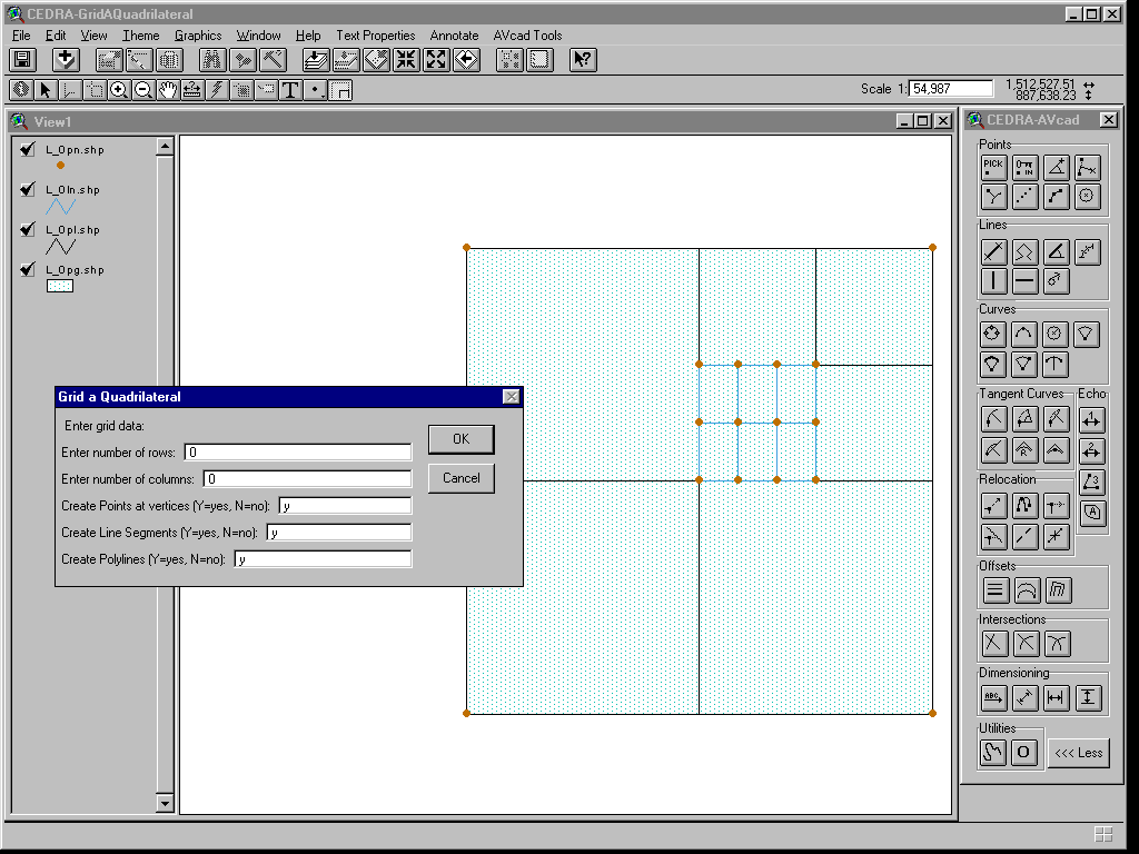
CEDRA-GridAQuadrilateralTM
Tools for dividing a Quadrilateral
CEDRA GridAQuadrilateralTM is an ArcView® GIS and ArcGIS® extension that is included with all of the CEDRA AVseriesTM software and enables the user to subdivide quadrilaterals, as well as most any irregular shaped polygon, by specifying the number of rows and columns that are desired. This is an ideal tool for those involved with quarter-quarter sections or Aliquot parts. For ArcGIS users, the [Aliquot Polygon] command within the CEDRA-Aliquot-Tools toolbar provides additional functionality for transcribing Aliquot descriptions thereby facilitating the generation of polygon features, which represent an Aliquot description.
![[Aliquot Polygon]](images/GRDQUAD4.GIF)
|
|
 |
CEDRA GridAQuadrilateralTM
CEDRA-GridAQuadrilateralTM
is an ArcView® GIS and ArcGIS® extension that enables
the user to subdivide a polyline or polygon
feature. In using this tool, the user selects one or more
polygon or polyline features, which form a closed figure, and
divides them into a user specified number of columns and rows.
The result of which, is a number of cells or grids within the
boundary of the feature(s).
There is no limit to the number of cells that can be created.
If only rows are desired then the number of columns specified
by the user should be 1. Likewise, if only columns are desired,
the number of rows should be 1
Additionally, the user has the option of creating, for each of
the selected features, any or all of the following:
(a) two-point line features that delineate the columns and
rows,
(b) point features at the intersection of each column and row
delimiter,
(c) polyline features, each forming a closed figure circumscribing
each cell defined by the specified columns and rows, and/or
(d) polygon features, which circumscribe each cell.
If more than one feature has been selected for processing, the features do not need to be located in the same layer. The features to be processed can reside in various active visible layers. Note that as a result of the processing by this tool, the selected feature or features are not altered. The new features which are created are stored in the current active layer. The [Set Active Layer] command can be used to control the current active layer.
Although this tool may be used on most any polygon or closed polyline, the tool was originally developed to divide a section, as per the US Department of the Interior Bureau of Land Management (BLM), into aliquots. As such, the tool assumes that the feature to be so divided would look fairly much like a BLM section, that is, a four-sided figure (quadrilateral).
In dividing a quadrilateral, the
program can operate in one of two modes. The first divides
each of the two sides that lie fairly much in a west to east direction
into the number of user specified columns, and each of the other
two sides that lie fairly much in a south to north direction into
the number of user specified rows. The corresponding points are
then joined to create the user specified cell or grid.
The second mode enables the user to divide a polygon feature
or a polyline feature which forms a closed figure using purely
horizontal and vertical lines to create the appropriate number
of rows and columns. This mode of operation differs from the first
mode in that the first mode honors the direction of the south-north
and west-east sides of the feature being subdivided, while the
second mode uses purely horizontal and vertical split lines, thereby
ignoring the slopes of the four sides
The selection of the feature or features, to be processed,
may be made before, or after the activation of this tool. However,
if the features to be processed are not contiguous, that is to
say, they can not be selected by clicking and dragging the mouse
to select the features in one operation. The features, in this
case, must be selected prior to the activation of said tool. Note
that, even if the features are continuous, or if only one feature
is to be divided, the selection can still be made prior to the
activation of said tool, if so desired.
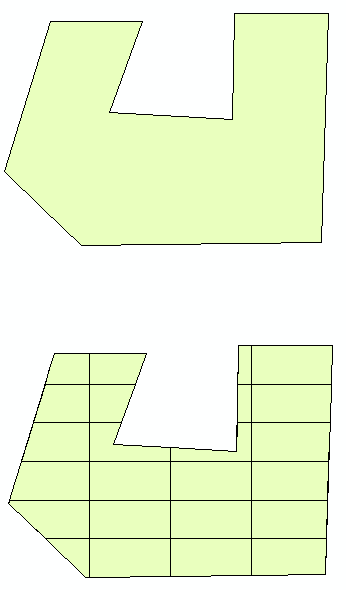
In the figure shown below, examples of the two modes of polygon
subdivision are shown. Both polygons are subdivided into 6 rows
and 4 columns. The polygon subdivided using Mode 1 illustrates
how the side slopes of the polygon are maintained, while the polygon
subdivided using Mode 2 demonstrates the use of pure horizontal
and vertical split lines in subdividing the polygon. Depending
upon the application, the user selects the mode which best fits
their requirements. Note that it is possible for the user to store
with the newly created polygons, the layer and OID of the feature
that was processed, as well as, a polygon counter which begins
at 1 and is incremented sequentially by 1. In the examples shown
below, the newly created polygons would have a polygon counter
value of 1 through 24.
|
|
|
 |
 |
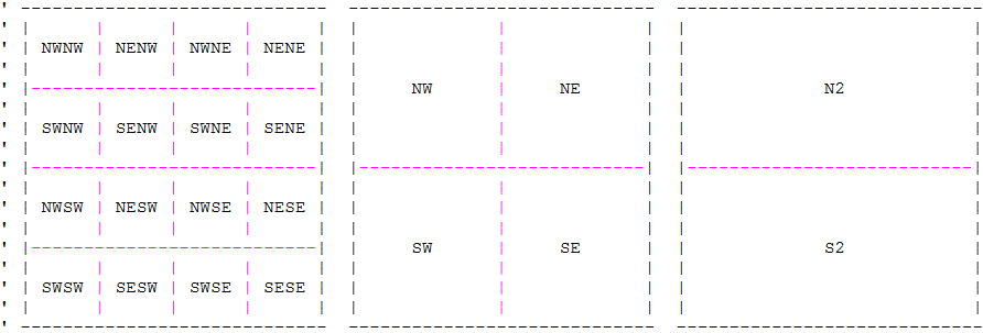
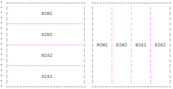
CEDRA-Aliquot-Tools ToolbarTM
The basic concept in an Aliquot description is to take a large
polygon, which typically represents a section in a grid system,
and subdivide it one or more times into a smaller polygon by using
various combinations of quadrant identifiers such as NE, SE, SW,
NW, N2, E2, E2W2 and so forth. The result of one quadrant identifier
serves as the starting point for the next quadrant identifier.
The [Aliquot Polygon] command within
the CEDRA-Aliquot-Tools toolbar provides the user the ability
to transcribe or decipher an Aliquot description thereby facilitating
the generation of polygon features which are defined in terms
of Aliquot quadrant identifiers.
The supported Quadrant Identifiers include the following:
|
|
 |
 |
 |
In addition to the Quadrant Identifiers, the user is able to
specify any of the Strip Identifiers, North, South, East and West
to extract a strip or portion of land from a quadrilateral. When
specifying a strip identifier, the user enters a strip width value
indicating the amount of land to be extracted.
|
|
|
|
For more information on CEDRATM software and services click on this link to Send an E-mail to CEDRA