CEDRA-AVparcelTM
Parcel Mapping
CEDRA AVparcelTM is an ArcView®
GIS and ArcGIS® extension, which includes and expands upon
CEDRA AVcadTM,
to provide tax (cadastral) mapping, parcel maintenance and general
Polygon Editing. All of the functionality of CEDRA AVcad is included
in CEDRA AVparcel plus more. Visit the CEDRA
AVcadTM page for a listing
of the functionlity offered by AVcad, and found in AVparcel, as
well as review the AVparcel specific functionality identified
below.
Join the many Assessor's, Planners, State Archives, Oil and Gas
Companies and Utility Authorities that use CEDRA AVparcel to manage
their parcels, leases and land boundary information within an
ArcView or ArcGIS environment. Use CEDRA AVparcel and take advantage
of the ability to snap between and within themes, handle unlimited
number of parcels, utilize state plane or UTM coordinates, define
customized PIN formats, handle chains and rods, veras, create
buffers and a host of other features listed below.
In addition to the mapping tools, CEDRA AVparcelTM provides functionality for editing attribute data using customized dialog boxes. The CEDRA-DataEditorTM extension, which is included with CEDRA AVparcel, enables the user to identify the specific themes and attributes which the user can edit. Quality control and data verification tools are included with the CEDRA-DataEditor extension to ensure that the database is properly maintained. The customized dialog boxes, which the user defines, are established without having the user write any Avenue, Visual Basic or other programming language software. With a simple point and click, CEDRA DataEditor users are able to edit and maintain their tabular information without having to start and stop table editing sessions.
ArcGIS users should check out the CEDRA-ArcView3-Tools toolbar. This toolbar offers a number of selection tools which will increase productivity by at least 30%. This is accomplished by reducing the number of clicks that are made in performing typical selection operations. ArcGIS users who have previously worked with ArcView GIS will definitely appreciate these tools.
To download an order form for a demo version of CEDRA-AVcad with Tutorial Manual click on the link. Once the order form has been downloaded, fill-in the requested information at the bottom of the form and then fax, e-mail or mail the order form back to The CEDRA Corporation. To see what's included in the demo version of the software click here CEDRA Demo Pack Information.
Those interested in a lot more functionality for just a little more expense should check out the CEDRA-AGsuite software package.
To download a PowerPoint slide show "right-click"
on this link (2.05 MB) and select the Save Target As... menu
item. Note that you must have PowerPoint or the PowerPoint Viewer
to display the slide show. To view the slide show in your web
browser, "right-click" on this
link (3.24 MB) and select the Save Target As... menu item.
Once the appropriate file has been downloaded, simply "double-click"
on the file to start the slide show. To advance to the next slide
in the PowerPoint or PowerPoint Viewer version, depress the Enter
key or the right arrow key. The web browser version will display
notes or additional information pertaining to the slide just below
the display of the slide. Furthermore, to advance to the next
slide, in the web browser version, the user "single-clicks"
on the desired slide number which is displayed on the left side
of the application window. Both versions of the CEDRA-AVparcel
slide show are comprised of 11 slides.
Click on this link for a color brochure,
which can be viewed and/or printed with Adobe Acrobat® ReaderTM.
|
|
 |
CEDRA AVparcelTM
CEDRA AVparcelTM is fully compatible with Versions 3.0, 3.1, 3.2 and 3.3 of ArcView® GIS and Versions 9.3, 10.0, 10.1, 10.2, 10.3, 10.4, 10.5, 10.6 and 10.7 of ArcGIS®.
CEDRA AVparcelTM provides the following functionality:
Building the database from within AVparcelTM
- Geometric layout of parcel corner and curvature points, boundary sides and polygons, multi-course tie-lines, and centroids in an interactive graphic environment.
- Topological data structure enabling CEDRA AVparcelTM to recognize shared sides.
- Ability to "clean" all parcels or a selected set of parcels, thereby eliminating duplicate and dangling parcel corners.
- Ability to enable or disable automatic "cleaning" of parcels.
- Databases created may represent:
- Parcel ownership,
- School districts,
- Fire safety districts,
- Drainage districts,
- Political boundaries,
- or any other special district delineation.
- Support of associate tables for Ownership, Taxation, Land use, Water use, etc.
- Support of a variety of coordinate systems such as State Plane, UTM, latitudes-longitudes, etc.
- Ability to specify measures in feet, meters, varas, chains, rods, etc.
- Ability to create, edit and maintain attribute data with the CEDRA-DataEditorTM extension.
Geometric functionality
- Includes and expands CEDRA AVcadTM.
- Direct deed transcription with or without tie-lines, and optional forced parcel closure.
- Deed transcription using the Parcel and Traverse Course Entry Form
which provides the ability to:
- Create line, tangent curve and non-tangent curve courses.
- View all of the courses, including the tie-line, which comprise the parcel or traverse in a table with a scroll bar.
- Modify a course description and have the parcel or traverse redrawn without terminating the deed transcription session.
- Easily insert a course without having to re-enter previous course data.
- Change the view during the deed transcription process.
- Zoom to the extent of the parcel or traverse.
- Display the error of closure as a ratio of the overall parcel or traverse length divided by the closure distance.
- Display the error of closure as a distance and as DX and DY values.
- Display the error of closure ratio (i.e. 1:5000, 1:10000, etc.).
- Create a formal report of the courses which have been defined that can be printed or viewed in any word processor or text editor.
- Deed transcription using a multi-input dialog box where in transcribing a deed the previous course data is displayed as the defaults for the next course entry.
- Ability to modify a traverse or string of features using a table entry form.
- Polygon creation given three sides and an area.
- Automatic determination of centroids and areas.
- Three dimensional database for application to high rise condominium type of ownership.
- Computational and deed record attributes of boundary key elements, areas, record books, and survey information.
- Automatic polygon creation using auto-search (tracing) functionality.
- Ability to mass convert polygons into topological parcels.
- Individual point, line, circular arc and spiral definition.
- Point and line traversing.
- Tangent line and curve generation.
- Ability to insert, delete and relocate vertices of a polyline or polygon.
- Specification of angles in decimal or degrees/minutes/seconds form.
- Specification of angles as an Azimuth, Bearing or Cartesian direction.
- Ability to create polygons within a quadrilateral by specifying the number of rows and columns.
- Point Snapping across themes.
Database query and editing
- Precise geometric location.
- Parcel location by number and area range.
- Parcel corner relocation and side modification.
- Parcel translation, rotation, biaxial scaling and deletion.
- Non-graphic attribute editing.
- Polygon splitting, joining and editing of vertices.
- Polygon split line may be a single line or a series of contiguous line features.
- When splitting a polygon, the attribute values of the original polygon are transferred to the new polygons that are created as a result of the splitting.
- Ability to extract a polygon part from a multi-part polygon.
- Ability to store geometric and deed data with deed data being independent of the geometric data.
- Ability to specify customized parcel attributes.
- Ability to customize the topological data structure.
Parcel Closure Adjustment
- Ability to adjust open or closed traverses.
- Crandall, Compass, Transit and Least Squares adjustments with formal report generation.
- Parcel closure data stored as attributes within the parcel
database. This includes:
- Flag denoting if parcel, when initially defined, forms a closed polygon (Yes or No),
- Closure distance from parcel start and end points.
- Closure differential distance (dx,dy) from parcel start and end points.
- Closure azimuth and bearing directions.
Parcel Identification Numbers (PIN)
- Single alphanumeric string of user-defined length.
- Support of New York State Office of Real Property Services (ORPS) format.
- Ability to create a user-defined PIN format comprised of up to eight individual components.
- Support of the Texas-Urban and Texas-Rural Print-Key equations for PIN generation.
- Ability to handle multiple parcels with the same PIN.
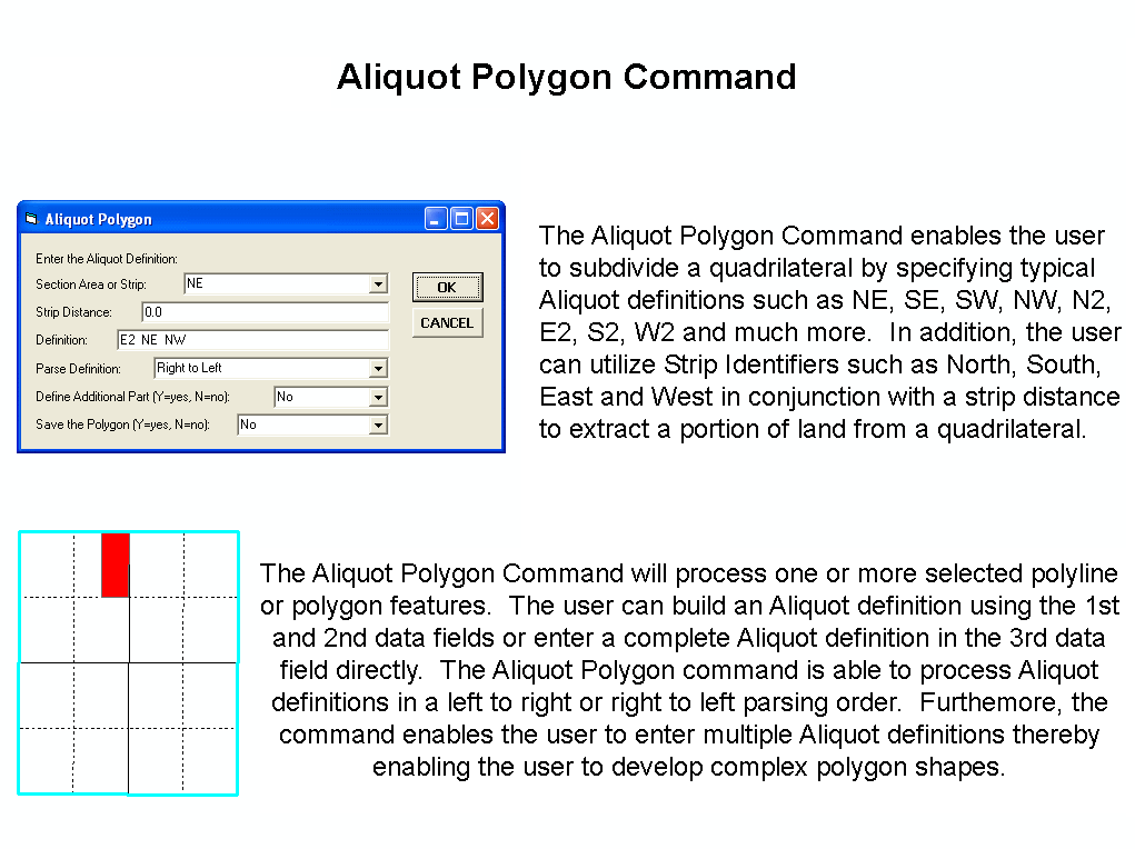
Aliquot Parts/Parcels
- Support of section identifier:
- ALL
- Support of quadrant identifiers:
- NE SE SW NW
- Support of half section identifiers:
- N2 E2 S2 W2
- Support of individual parcel/lot identifiers:
- NENE NESE NESW NENW
- SENE SESE SESW SENW
- SWNE SWSE SWSW SWNW
- NWNE NWSE NWSW NWNW
- Support of North/South/East/West half quadrant identifiers:
- N2NE N2SE N2SW N2NW
- E2NE E2SE E2SW E2NW
- S2NE S2SE S2SW S2NW
- W2NE W2SE W2SW W2NW
- Support of North/South and East/West half section identifiers:
- N2N2 E2E2 N2S2 E2W2
- S2N2 W2E2 S2S2 W2W2
- Support of strip identifiers with the ability to specify
the strip width value:
- North South East West
- Ability to create a multi-part polygon with a single description.
The example below results in a three part feature being created.
The comma character delineates the individual parts.
- NE NE ,SW ,SE SE
- Ability to mass create polygons
based upon an Aliquot description that is stored in an attribute
of a table. Note the following:
- the user must load a dBase table (.dbf) into the data frame and activate or select a layer which may be of polyline or polygon type (the active layer),
- this active layer represents the sections or grids for which the Aliquot descriptions pertain to,
- the dBase table must contain three fields representing the Township, Range and Section values for the section or grid to be subdivided. The active layer must also contain these same three fields,
- the selected records in the dBase table are processed, if there are none, then all records in the table are processed,
- as a record is read from the table, the active layer is searched for a match on the Township, Range and Section values which were read from the table record,
- if there is only one match then it is this section or grid that is subdivided, if there are no matches or more than one match, then the table record is ignored and the next record in the table is processed,
- the user has the option to transfer attributes or fields from the dBase table to the current active layer which will contain the polygons that are created.
- Ability to parse Aliquot descriptions in a left to right or right to left order.
Importing functionality
- dBase, Info, SDE and ASCII files may be directly read.
- Access, Paradox, FoxPro, Oracle, Sybase, Informix, DB2, Ingres
by:
- Exporting to dBase or ASCII for direct reading or,
- accessing through ODBC - Open Database Connectivity.
- any ODBC/SQL-compliant database.
- Import of PC Arc/Info coverages, Arc/Info coverages and libraries.
- Direct reading of Shapefiles.
- DXF, DWG, DGN and CEDRA CAD drawings.
- VPF, MapInfo, Atlas GIS and ASCII map data.
- Ability to have comments within the ASCII files that are processed for mass importing.
- Ability to mass import polygons from an ASCII file.
- Ability to mass import points in a variety of formats from an ASCII file.
- Ability to mass import lines that are defined by node numbers from an ASCII file.
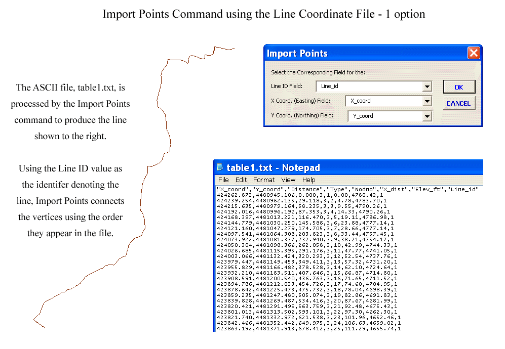
- Ability to mass import polylines that are defined by a line ID value and vertex coordinates from an ASCII file.
- Ability to import a CEDRA "COGO" file which is
an ASCII file that allows the user to mass import:
- Lines given a direction and a distance.
- Polygons given a direction and a distance for each course (side) comprising the polygon. The polygons may also contain curves (simple, compound and reverse) rather than just straight line sides.
- Non-Tangent Curves given a chord direction, a chord length and a radius.
- Tangent Curves given a chord length and a radius.
- Tangent Curves given an arc length and a radius.
- Tangent Curves given a central angle and a radius.
- Ability to display the following raster file formats:
- TIFF (.tif files).
- ERDAS (Rev 7.3 and 7.4 .lan and .gis files).
- IMAGINE (.img files).
- BSQ, BIL and BIP.
- Sun Rasterfiles (.rs, .ras, and .sun files).
- BMP.
- JPEG (.jpg files).
- IMAGINE (.img files).
- Arc/Info GRID.
- RLC (Run-Length Compressed format).
Exporting functionality
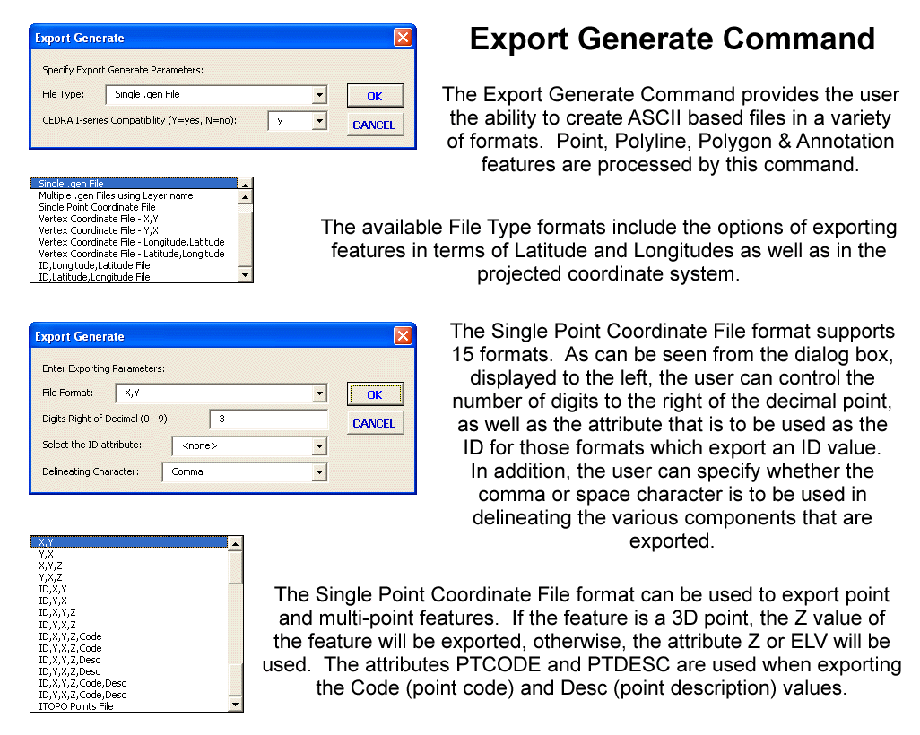
- Ability to export features (points,
lines, polygons and annotation) as an Arc/Info Generate File.
- In the form of a single Generate file, or
- As multiple Generate files using the layer name as the name of the file.
- Ability to export features (points,
lines and polygons) in the form of a Vertex Coordinate File.
- In the form of X,Y coordinates,
- In the form of North,East coordinates,
- In the form of Longitude,Latitude coordinates, or
- In the form of Latitude,Longitude coordinates.
- Ability to export features (points, and multi-points) in a variety of ASCII based formats.
- Ability to export features (points, lines, polygons and annotation) in the form of a DXF File.
- Ability to export features (polylines and polygons) adhering to the Traverse File Format.
Graphic display manipulation
- Preparation of parcel maps with the ability to customize map templates.
- Mass Annotation of parcel identification numbers, area and centroids.
- Advance or return to previous views.
- Ability to save and assign a name to an unlimited number of views.
- Ability to return to a previous view by specifying a view name.
- Ability to zoom in or out of a view by specifying a scale factor.
- Individual and global text scaling.
- Individual and global text editing.
- Viewing of ASCII based files.
- Customized selection tools for ArcGIS users.
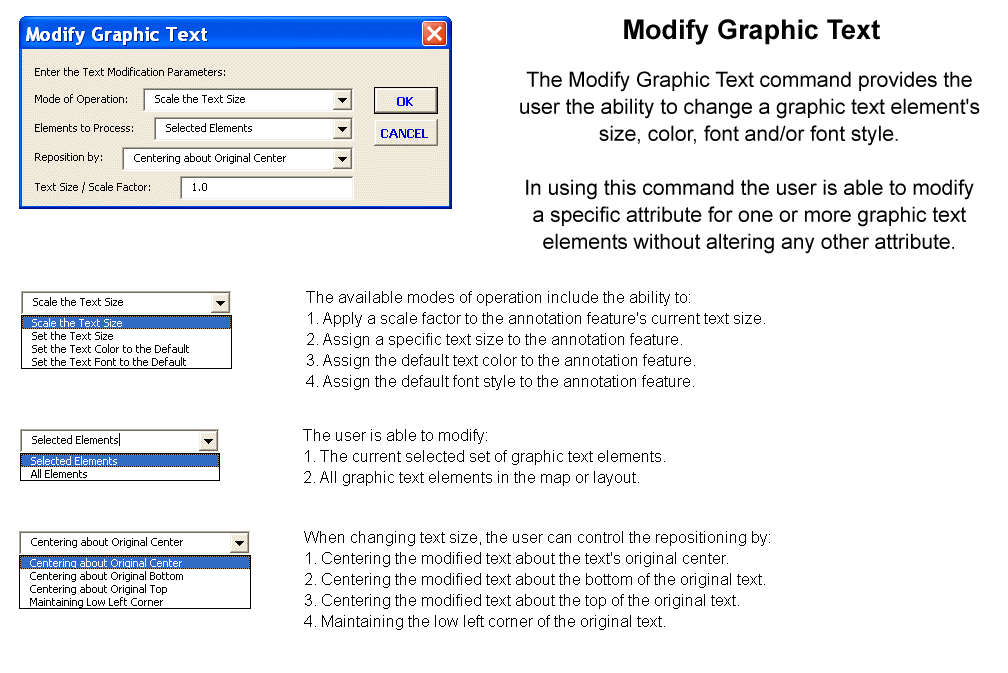
- Ability to modify a specific attribute of one or more graphic text elements without altering any of their other attributes.
CEDRA-AVparcel Tools toolbar for ArcGIS
ArcGIS users can access the CEDRA AVparcel tools via the CEDRA-AVparcel Tools toolbar. This toolbar can be docked at the top or bottom or to the left or right side of the ArcMap or ArcCatalog windows. Alternatively, the toolbar can float on the desktop while functioning as part of the application. When you dock the toolbar, it is moved and resized with the application's window. CEDRA AVparcel tools will operate on topological parcels, as well as, polygon features.
|
|
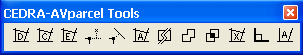 |
Functionality offered by the tools in the CEDRA-AVparcel Tools toolbar, proceeding left to right, includes the ability to:
- Define parcels/polygons by (a) entering bearings/distances, or (b) auto-searching existing line/curve features.
- Define parcels by converting existing polygons into topological parcels.
- Edit parcel attributes.
- Move line(s)/curve(s) endpoint to point of projection on another line/curve adjusting parcels.
- Move point(s) to point of projection on a line/curve adjusting parcels.
- Find the area and perimeter of a parcel/polygon.
- Split a parcel/polygon based upon a user specified line.
- Unite parcel/polygon with other parcels/polygons to form new parcel.
- Combine parcel/polygon with other parcels/polygons to form new parcel/polygon.
- Delete a Parcel.
- Pick line along which polygons are to be squared.
- Create a Polygon given 3 Sides and an Area.
Printing Capability for ArcGIS
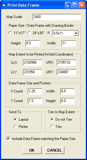
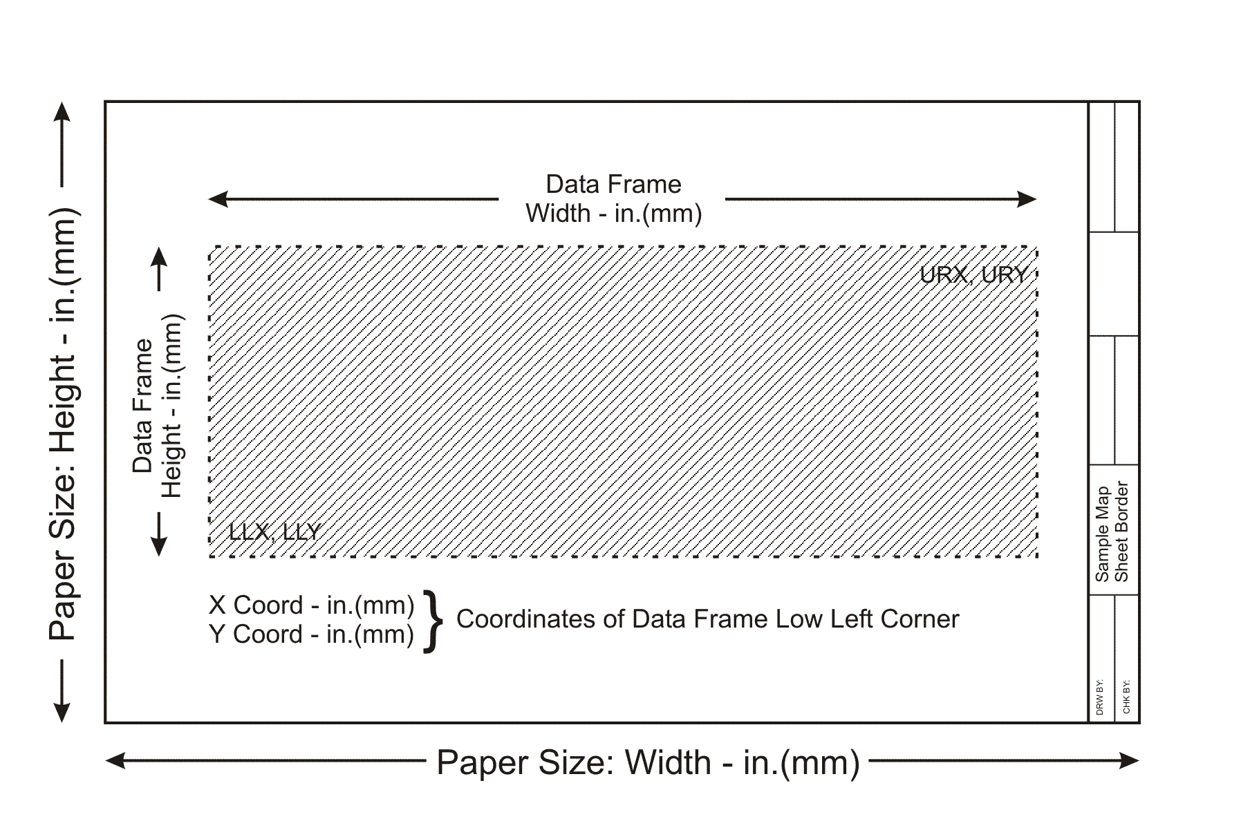
ArcGIS® users have the ability to print the active data
frame using the Print Data Frame command, which is available in
the CEDRA-DataFrame-Tools toolbar. The Print Data Frame command
differs from conventional ArcGIS printing in that the user is
able to control: (a) the map scale, (b) the map area to be printed,
(c) the location of the map on the paper and (d) optionally, whether
a data frame, which contains a map sheet border, should be included
or not in the map.
As most ArcMap users have realized, within an ArcMap document
file (.mxd) all data frames share the same layout. This causes
the difficulty of when the layout view is activated all of the
data frames in the document file appear in the layout, which for
some applications is not what the user wants. The Print Data Frame
command will print the active data frame, from data or layout
view, ensuring that: (a) the desired map scale is preserved, and
(b) all other data frames do not appear on the plot. This is achieved
by programmatically positioning all data frames, other than the
active data frame, in the document file outside of the user specified
sheet limits (Paper Size parameters). In so doing, when the layout
view is activated the only data frame that appears in the layout
view is the active data frame.
This capability allows the user to have a single document file
that contains many data frames with each data frame containing
a complete drawing sheet. Without the Print Data Frame command
the user would have to: (a) create separate document files for
each drawing sheet or (b) manually reposition all data frames,
other than the active data frame, outside of the sheet limits.
|
|
|
|
|
|
In addition, users have the ability to operate in another mode
of map preparation. The first mode, which was described above,
is when a single data frame contains the entire map to be printed.
The second mode is where one data frame contains the map contents,
while another data frame contains the map border (title block,
sheet border, etc.).
The Print Data Frame command accommodates this scenario by providing
the Include Data Frame matching the Paper Size option.
When this option is checked the Print Data Frame command will
position the active data frame according to the specifications
in the Data Frame Size and Position parameters area and will include
in the plot the data frame whose name is either 11"x17",
24"x36" or Custom, depending upon which Paper Size is
active. This approach enables the user to create a single map
border, placing it in a data frame using one of the following;
11"x17", 24"x36" or Custom
as the name of the data frame, and generate multiple maps without
having to load the map border into multiple data frames.
DXF Export Capability for ArcView GIS and ArcGIS
ArcView® GIS and ArcGIS® users have the ability to create a DXF file, from within ArcView 3.x or ArcMap, for all visible features in the current map. Unlike other DXF export utilities, which process only one theme at a time, the CEDRA DxfExportTM extension processes all visible themes (shapefiles, personal geodatabases, enterprise geodatabases and coverages) in the current map. In addition, the CEDRA DxfExport utility will process annotation features and graphic text elements. As such, a DXF file created by this utility can include features and text. In processing the visible layers in the map:
- If a theme has selected features then only the selected features will be processed, if there are no selected features then all features in the theme will be processed, this includes point, polyline and polygon features. If the option Export Features displayed in the Current Extent is selected then all visible features in the current view will be exported regardless of the feature's selection state.
- If a theme has labels, the labels will need to be converted into annotation, using the Convert Labels to Annotation... command, in order for the labels to be exported. The labels that are converted can be stored either in a personal geodatabase or in the map, depending upon the user's preference.
- If there are selected MARKER, PEN, FILL and/or TEXT graphic
elements then these graphic elements will be processed (if the
user desires). If the view does not contain any selected graphic
elements then no graphic elements will be processed. In exporting
graphic elements note the following:
- All of the selected Marker elements will be placed in a layer called GrapMrkr,
- All of the selected Pen elements will be placed in a layer called GrapPen,
- All of the selected Fill elements will be placed in a layer called GrapFill, and
- All of the selected Graphic Text elements will be placed in a layer called GrapText.
- The name of the theme will serve as the name of a layer in the DXF file.
- Non-alphanumeric characters in a theme name are converted to the underscore character (_).
- The user has the ability to select one or more attributes, from a choice box that appears in the Create DXF File dialog box, for inclusion in the DXF file, if desired. When exporting attributes, the selected attributes will appear as "blocks" in the DXF file. These blocks will appear at the midpoint of the feature and the name of the block will be B_xxxx, where xxxx denotes the name of the layer the feature resides in. All of the attributes associated with the block will be listed vertically, one under the other. The ability to export attributes is important because: (a) it enables the user to transfer non-graphic information (attributes) into the DXF file, maintaining the association of the non-graphic information with the feature and (b) provides a mechanism for the user to maintain symbology and line styles. Regarding the latter, symbology and line styles, in the GIS classifications are based upon attributes, by exporting the attributes which the classifications are based upon, the user has the ability to regenerate the classifications in the system in which the DXF file is being read into. This, of course, is dependent upon the software which is reading the DXF file, that it has the ability to change symbology and line style using information that is stored in a "block".
| ArcMap - CEDRA-DxfExport Dialog Box |
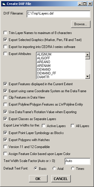 |
As can be seen by examining the dialog box above, the user is able to:
- Control the name of the DXF file that is created. The Browse... button enables the user to use a standard file navigation dialog box to control the folder where the DXF file will be written to, as well as the name of the DXF file.
- Specify whether the theme names are to be trimmed to 8 characters or not. If a check appears in the square to the left of this parameter, the names of the visible themes that are processed will be trimmed to a maximum of 8 characters. The first 8 characters of the theme name will be used.
- Specify whether selected graphic elements are to be included in the DXF file creation. If a check appears in the square to the left of this parameter any graphic elements that are selected will be included in the creation of the DXF file.
- Specify whether a DXF file for importing into the CEDRA I-series software is to be created or not.
- Specify which attributes if any are to be included in the DXF file as "blocks". If a check appears in the square to the left of this parameter all attributes which are selected in the choice box will be included in the DXF file as "blocks". There is no limit to the number of attributes that can be selected, and
- Specify whether the visible features in the current extent (view) are to be processed. If a check appears in the square to the left of this parameter then the only features that will be exported will be the visible features in the current extent, regardless of their selection state. In addition, if the Export Selected Graphics (Marker, Pen, Fill and Text) option is selected, all Marker, Pen, Fill and Graphic Text elements in the visible annotation group layers which are within the current extent will be exported, regardless of their selection state. The name of the annotation group layer will serve as the name of the layer these graphic elements are placed in.
- Specify whether the data that is exported is to appear in the same coordinate system as the current view (data frame) or not. If this option is not checked, the data that is exported will be in the coordinate system of the theme's (layer's) source data. If this option is checked, all data that is exported will be in the same coordinate system as currently displayed in the data frame.
- Specify whether features are to be clipped to the current map display extent when exporting from Data View. If this option is not checked, if any portion of a feature falls within the current map display extent, the entire feature will be exported. If this option is checked, the feature will be clipped to the current map display extent prior to exporting.
- Specify whether polyline and polygon features are to be exported as LWPolyline AutoCAD entities. If this option is checked, all polyline and polygon features will be exported as a LWPolyline entity, rather than a Polyline or Polygon entity. If a polyline forms a closed figure then a closed LWPolyline entity will be exported.
ArcView 3.x Tools for ArcGIS
ArcGIS users who have worked with ArcView GIS will notice that the commands shown below: (a) do not operate the same in ArcMap as they did in ArcView or (b) are just not a part of core ArcGIS. These commands did not provide GIS functionality but they were an essential part of how ArcView GIS users operated in the ArcView 3.x environment. To ease the transition to ArcGIS, CEDRA's ArcGIS based software includes the CEDRA-ArcView3 Tools toolbar. This toolbar enables ArcGIS users to interact with ArcMap in a manner similar to how ArcView GIS users operated in the ArcView 3.x environment. For users who have never worked with ArcView GIS, these tools provide an easier and more flexible means of interacting with the map.
| CEDRA-ArcView3 Tools toolbar |

|
Functionality offered in the CEDRA-ArcView3 Tools toolbar
- Identify features from the active layers in the Table of Contents.
- Select features from the active layers in the Table of Contents.
- De-select or clear the selected features from the active layers in the Table of Contents.
- Zoom to the extent of all layers in the Table of Contents.
- Zoom to the extent of the active layers in the Table of Contents.
- Zoom to the extent of the selected features in the active layers in the Table of Contents.
- Make all layers in the Table of Contents visible.
- Make all layers in the Table of Contents invisible.
- Delete the selected features in the map with a single click eliminating the need to (a) start the Editor, (b) select the appropriate dataset and (c) select the delete command.
- Delete a group of vertices in a selected polyline or polygon feature by defining a rectangle that encloses the vertices to be deleted.
- Open the attribute table for the selected layer(s) and/or table(s).
- Switch or reverse the selection set for the selected layer(s) and/or table(s).
- Set the current active layer (Target Layer) by picking the desired layer from an alphabetically sorted list of layer names and clicking the OK button.
To download a color brochure, which can be viewed and/or printed with Adobe Acrobat® ReaderTM, click on the following link CEDRA Software Information.
CEDRA-AVparcel is licensed as per the terms of the CEDRA Software License Agreement.